Announcement: My online Land Navigation course includes four hours of video instruction, and two downloadable PDF books, all for about the same price as a typical paperback book. Get my Land Navigation course here.
Compass Navigation
For purposes of this page, "compass navigation" means finding your way cross country with only a compass, and no map.
Read what's on this page for background info on compass navigation, then watch my 15-minute video on how to navigate with only a compass. This is a great skill to have.

Learn Land Navigation Now. Enroll in my personalized step-by-step video-based online course. We'll start from the beginning, and go through everything you need to know to find your way over the terrain. With solid land-navigation skills, you'll be more confident and "at home" in the wilderness. Plus, as a web site visitor, you get a 50% discount off the regular price, meaning you get the whole course for $10. ENROLL NOW.
Scenario
Let's say you're cruising along a forest road in your Jeep and you want to park your vehicle, and walk off into the forest to explore, photograph, hunt, whatever.

You can explore the terrain and find your way back,
even without a map
Your problem is you don't have a map, but you do have a compass. Not to worry. Even without a map, using only a compass and dead reckoning, you can still travel around the terrain, and find your way back to your starting point. You won't know what terrain features are there until you encounter them, but you can still find your way around the countryside and back to your starting point with a compass only, and no map.
What do Do
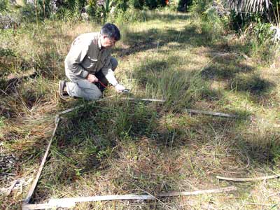
To do this, you'll use what I call "mapless dead reckoning," meaning you'll use a small notebook to record the directions and distances you travel. Any particular direction and distance segment of your travels is called a leg. When you're ready to return you'll plot each leg of your travels, either on paper, or by laying out your plot using sticks on the ground. Your plot will give you a bird's eye view of your travels, and will indicate the direction and distance back to your starting point.

Using sticks to plot the legs of your travels across the terrain
It Was Good Enough for Columbus
Compass navigation is pretty much what Christopher Columbus did. After all, he had no map (or chart, as mariners call it) when he sailed west out of Spain on that hot August day in 1492. He had little clue where he was going. He knew only that he was going west. He later sailed all around the Caribbean, thinking he was in China. When he was ready to come home, he more or less sailed east and made it back to the large baseline of the European coast, Portugal to be exact. He did this by dead reckoning.
You can do the same thing over a few kilometers of terrain. What you'll do is leave a certain known point along a baseline, say the road where you parked your Jeep.
You'll then make note of the compass headings you walk and you'll keep up with the distance along each heading, either by using watch time traveled, or by counting paces (see the page entitled "How Dead Reckoning Works" for info on time and pace count. You'll record each leg of your travels in a notebook. Then, when you're ready to return home, you'll plot each heading. Your plot will reveal the distance and direction back to your starting point along the baseline.
Know Your Safety Bearing
If you get totally messed up, you don't need to worry as long as you know the safety bearing back to your baseline. If you walked west off a north-south road, for instance, your safety bearing will be east. Just walk east and you'll find the road. Of course, you'll have to then figure out where your Jeep is, but at least you've found the road. Accurate compass navigation, however, promises to get you back somewhere in the vicinity of your Jeep. You might even use the trick of aiming off on your return leg so you'll know which way to walk to find your vehicle once you come to the road.

